
Mobile mapping platforms that use Simultaneous Localization And Mapping (SLAM) have been rising in popularity among surveying professionals across a variety of industries. While these detailed maps can be captured quickly and easily, they sometimes suffer from accumulated drift or misalignment that can make them globally inaccurate. But don't throw out that data just yet! One way to correct those error sources is to use Exyn’s geo-referencing and GCP anchoring pipelines.
Geo-referencing a point cloud means aligning the data with a known coordinate system. This process enables an accurate and realistic representation of the point cloud data within a geographic context and facilitates the integration of the data with other geospatial datasets like maps, BIM models, or satellite imagery.
 Illustration of iterations incorporating additional GCPs for non-rigid transformation.
When you think about the accuracy of a 3D point cloud, you have to separate it into local and global accuracy. Local accuracy is the accuracy of dimensions of objects and areas that are visible from sensor placements that are nearby the area or object of interest. As such, local accuracy is impacted by the accuracy and repeatability of the LIDAR sensor itself. Global accuracy, on the other hand, means how accurate the entire map is compared to real world measurements, such as previously captured ground control points or existing geospatial datasets. Global accuracy is impacted by drift, i.e. how well the SLAM algorithm can minimize error as the sensor traverses the space.
Ground control points (GCPs) are locations within a given area that have known coordinates. They are a key tool in the geospatial industry and can be used in a variety of ways throughout the construction and mining industries. By using control points, surveyors are able to accurately stitch several surveys of an area together.
ExynAI – the software stack powering our robots – is equipped with a powerful geo-referencing pipeline that survey teams can use directly on our ruggedized tablet. After extracting a PLY or LAS file from an exlog, or loading one into ExynView – our software to plan missions and process point clouds – ExynAI can automatically detect any present ground control points by looking for high intensity points. The control points we use are retro-reflective and can be seen by the LiDAR sensor even in complete darkness. Once the control points are detected, they are associated with known GCP coordinates. Users can associate points individually or simply let the powerful ExynAI algorithm choose them automatically.
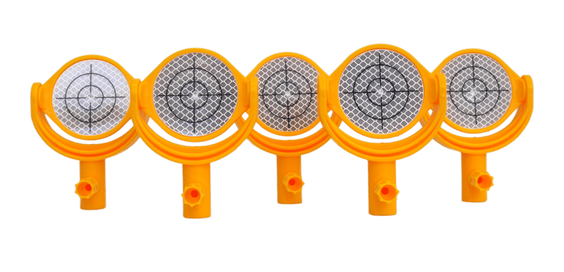 Ground control points that ship with the ExynAero & ExynPak
At the moment, there are two methods of utilizing GCPs within a dataset for positioning data within a global context and improving overall data quality each with their own merits: rigid and non rigid transformations.
Like the name implies, rigid transformations are a little stiff. Scans are rotated and adjusted by applying a combination of translation (movement in X, Y, and Z directions) and rotation (around the X, Y, and Z axes), without any change in the shape or size of the point cloud. It preserves the distances between points, angles between lines, and only modifies the orientation and location of the point cloud.
Rigid transformations work best when the effects of drift are relatively minimal and there is limited control scattered throughout the environment to utilize.
However, if there are additional ground control points present within the environment or additional ground control points can be added to the environment, more complex techniques can be used to increase the overall global consistency of the map and further reduce any accumulated error.
This method is better suited for environments that don't have rich geometry and are therefore challenging for LiDAR-based SLAM algorithms or sufficiently large captures where drift will inevitably impact the output map. Non-rigid transformation algorithms can improve the global accuracy of point clouds by utilizing known coordinates within the scan to provide additional anchors within the SLAM solution to correct any errors that were accumulated throughout the scan. Non-rigid transformations provide a more flexible alignment that can correct for systematic errors and improve overall accuracy.
When using non-rigid transformation models, it is essential to have a sufficient number of accurate and well-distributed control points to achieve reliable results.
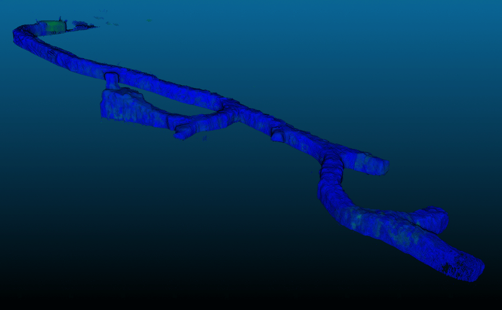 Non-Rigid GCP anchoring allowed map corrections increasing global accuracy
Geo-referencing point clouds is a crucial step in integrating LiDAR and other spatial data into a common geospatial coordinate system for accurate analysis and visualization. The choice between rigid and non-rigid transformation models depends on the characteristics of the point cloud and its alignment with the reference coordinate system.
Ultimately, the choice of transformation model should be driven by the specific requirements of the project, the nature of the data, and the desired level of accuracy, while also considering the availability of accurate and well-distributed control points.
To learn more about how non-rigid transformations can benefit your operation, reach out to your Exyn representative, or contact us.
