


With the Nexys ecosystem, users can choose to equip their autonomy payload onto a aerial- or ground-based robotic platform.
Leveraging Autonomy Level 4 (AL-4), the operator simply sets the area to scan and the system determines its own route to ensure complete environmental coverage, detects the 3D environment, and identifies and reasons about obstacles and high-level objectives - even in GPS-denied, hazardous, and unilluminated environments.
Learn More
Our industry-leading autonomous intelligence powers robots to carry out safer missions and capture otherwise impossible to reach data without the use of prior maps, GPS, or existing infrastructure.
Our autonomy also supports beyond visual line of sight (BVLOS) and out of range of communication flights, allowing the data to be collected onboard and streamed back to the user once back in range of communications.
Browse Autonomy Features


|
Point to Point |
Exploration |
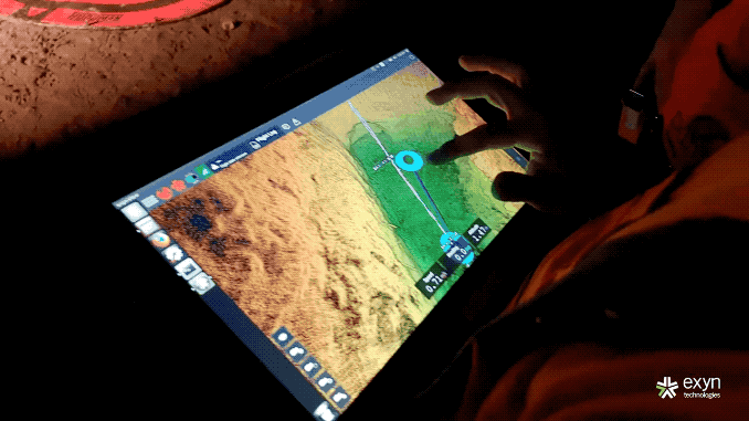
Exyn sets the industry standard for high-speed post-processing. Survey teams process the data collected right on the tablet, as soon as Nexys returns home. Whether still onsite or back at a control center, the entire process takes place on the edge and out of the clouds.


Engineered for flexibility, Nexys uses advanced artificial intelligence and machine learning to adapt to virtually any industrial application.

Learn more about our industry-leading autonomy and mapping ecosystem, built from the ground up for fast and accurate digital twin capture and post processing.
Request a meeting with our team today.

Exyn Nexys, powered by the industry's most advanced level of autonomy, enables our Level 4 Exploration Autonomy on Boston Dynamics' Spot agile mobile robot, allowing users to take advantage of our completely modular mapping solution on a robust, resilient terrestrial platform.
ExynAI'a autonomy can automate scanning, inspection or as-builting, perform routine inspections, warehouse operations monitoring, convergence monitoring, post-blast safety evaluations, or to remove people from difficult or dangerous mapping situations.


