In an era where technology continuously stretches the boundaries of possibility, 3D mapping is a testament to human ingenuity. This innovation has carved new avenues of understanding and operation within the construction sector and mining, surveillance, and disaster management industries. Find out more about Exyn's SLAM 3D mapping.
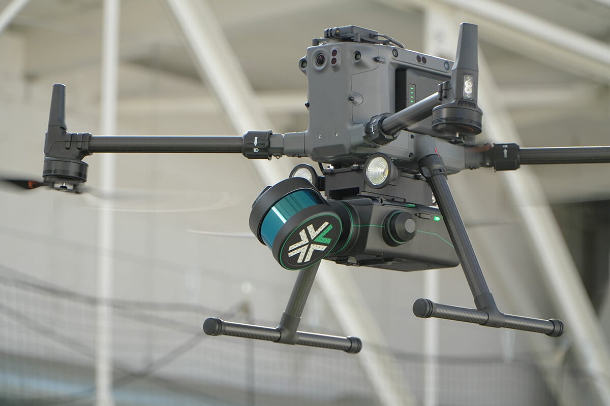
3D mapping is used successfully in many industries, including construction, land surveying, real estate, agriculture, forestry, and disaster management. This robotic technology allows surveyors to analyze survey-grade maps of previously unreachable locations in real time while the drone is in flight.
Exyn’s SLAM pipeline enables the robot to autonomously navigate many extreme field conditions, including GPS- and comms-denied environments with little to no light, communications with a pilot, or existing infrastructure.
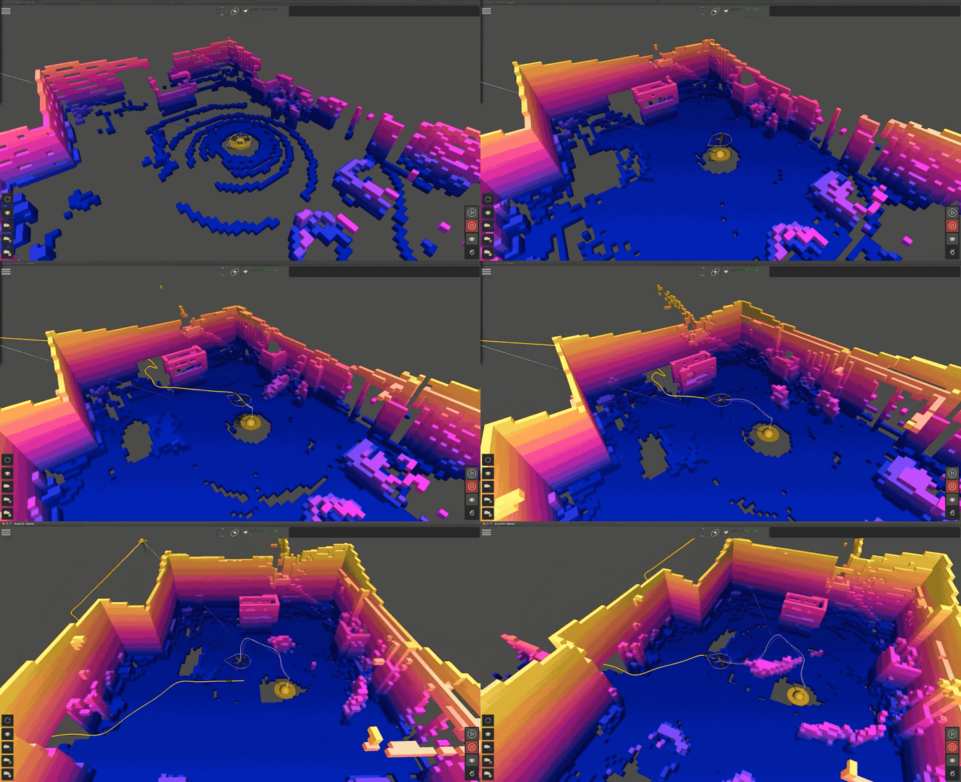
SLAM, or Simultaneous Localization and Mapping, is a sophisticated computational technique that enables robots, such as self-directed drones, to chart out unfamiliar environments while keeping track of their location. This ability is beneficial in areas where GPS signals are unreliable or unavailable. To discover more and embark on a journey of 3D autonomous mapping, click here.
Read More about SLAM
Online SLAM takes the driver's seat when robots are in action, detecting and dodging obstacles. Data processing must match its pace with a robot potentially covering ground at 2 meters/second. As the LiDAR assesses the terrain, algorithms like LIDAR Odometry and Mapping (LOAM) work behind the scenes to craft an evolving local map.
Interestingly, robots powered by ExynAI construct dual maps during navigation. One delineates edges, while the other focuses on surfaces. This on-the-fly mapping, combined with real-time adjustments, ensures robots sail smoothly through their environment.
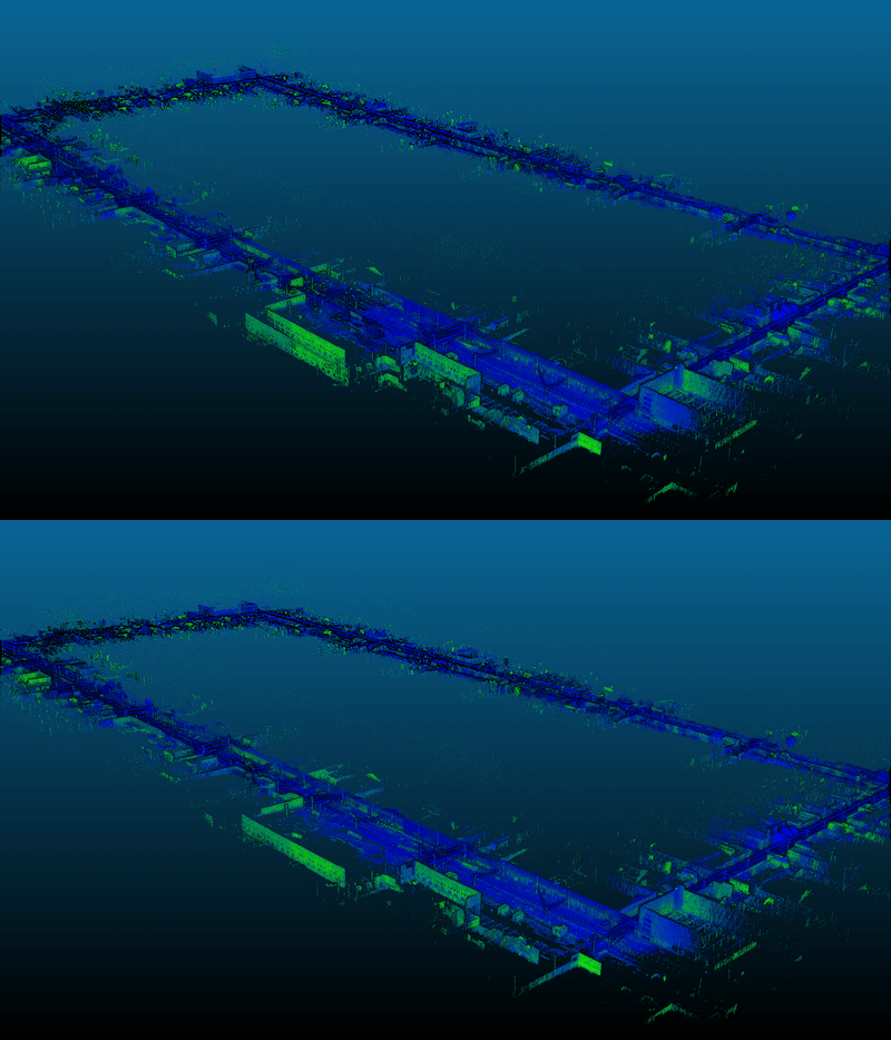
Once a robot's journey concludes, the spotlight turns to Offline SLAM. Here, the emphasis is on something other than speed – accuracy. The raw sensory data, logged throughout the journey, undergoes rigorous refinement. Enter ExSLAM, Exyn’s post-processing maestro. It gleans the point cloud data, refining and readying it for third-party applications.
A key aspect of Offline SLAM is the loop closure. As a robot roams, uncertainties about its exact position can accumulate. Loop closure is akin to a eureka moment when the robot realizes it has returned to a previously visited spot, allowing it to adjust and refine its internal map.

Online SLAM takes the driver's seat when robots are in action, detecting and dodging obstacles. Data processing must match its pace with a robot potentially covering ground at 2 meters/second. As the LiDAR assesses the terrain, algorithms like LIDAR Odometry and Mapping (LOAM) work behind the scenes to craft an evolving local map.
Interestingly, robots powered by ExynAI construct dual maps during navigation. One delineates edges, while the other focuses on surfaces. This on-the-fly mapping, combined with real-time adjustments, ensures robots sail smoothly through their environment.

Once a robot's journey concludes, the spotlight turns to Offline SLAM. Here, the emphasis is on something other than speed – accuracy. The raw sensory data, logged throughout the journey, undergoes rigorous refinement. Enter ExSLAM, Exyn’s post-processing maestro. It gleans the point cloud data, refining and readying it for third-party applications.
A key aspect of Offline SLAM is the loop closure. As a robot roams, uncertainties about its exact position can accumulate. Loop closure is akin to a eureka moment when the robot realizes it has returned to a previously visited spot, allowing it to adjust and refine its internal map.
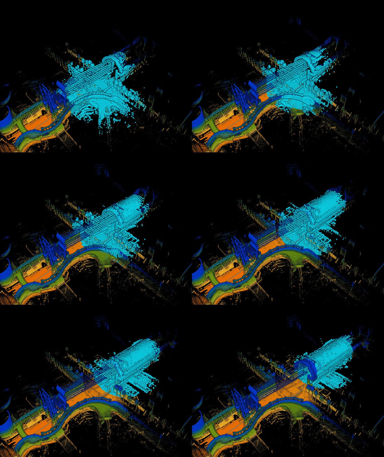
The SLAM horizon is promising. As technological advancements like colorization pipelines loom, the potential to superimpose RGB data on point clouds could redefine 3D modeling. Moreover, integrating GPS data in post-processing endeavors promises even more accurate and grounded mapping results.
As online and offline SLAM realms converge and evolve, how robots understand and navigate their world will continue to revolutionize. To read more about the nuances of online and offline SLAM systems, click here.
Graph SLAM constructs a world where connections and relationships are visualized as a graph. It creates a graph where each node represents a robot's pose or landmark, with edges to mark spatial constraints between them. By optimizing this graph, Graph SLAM irons out inaccuracies, resulting in a comprehensive and accurate map of the environment.
In the probabilistic realm, EFK SLAM employs the Extended Kalman Filter, a mathematical stratagem that predicts and corrects a robot's pose and landmark estimates. EFK SLAM continually refines its understanding of the environment through iterative prediction and correction based on sensor inputs.
Demonstration of EKF SLAM using Robotics Toolbox for MATLAB.
True to its name, Fast SLAM is built for speed. By harnessing particle filtering techniques, it efficiently estimates a robot's trajectory while concurrently mapping the environment. Its capability to handle large numbers of landmarks with minimal computational overhead makes it a favorite for many robotics experts.
As visuals dominate human understanding, Visual SLAM prioritizes optical data. This approach captures the environment in detailed images using a camera as a primary sensor. Sophisticated algorithms then decipher these images, extracting key features to construct a visual-rich map. The magic lies in how Visual SLAM combines these snapshots to craft a cohesive and navigable 3D map.
 Read more about the differences between visual SLAM and LiDAR-based SLAM.
Graph SLAM constructs a world where connections and relationships are visualized as a graph. It creates a graph where each node represents a robot's pose or landmark, with edges to mark spatial constraints between them. By optimizing this graph, Graph SLAM irons out inaccuracies, resulting in a comprehensive and accurate map of the environment.
In the probabilistic realm, EFK SLAM employs the Extended Kalman Filter, a mathematical stratagem that predicts and corrects a robot's pose and landmark estimates. EFK SLAM continually refines its understanding of the environment through iterative prediction and correction based on sensor inputs.
Demonstration of EKF SLAM using Robotics Toolbox for MATLAB.
True to its name, Fast SLAM is built for speed. By harnessing particle filtering techniques, it efficiently estimates a robot's trajectory while concurrently mapping the environment. Its capability to handle large numbers of landmarks with minimal computational overhead makes it a favorite for many robotics experts.
As visuals dominate human understanding, Visual SLAM prioritizes optical data. This approach captures the environment in detailed images using a camera as a primary sensor. Sophisticated algorithms then decipher these images, extracting key features to construct a visual-rich map. The magic lies in how Visual SLAM combines these snapshots to craft a cohesive and navigable 3D map.
 Read more about the differences between visual SLAM and LiDAR-based SLAM.
In 3D mapping, time and accuracy are of the essence. And Nexys makes quickly and accurately mapping easier than ever with its modular design and on-site post processing.

Autonomous 3D mapping technology has witnessed considerable advancements in the recent decade. Often, these modern techniques surpass the accuracy of traditional mapping methods.

Here's how these state-of-the-art tools are making a difference:
Safety remains paramount when surveying complex and potentially hazardous environments. Leveraging advanced remote technologies ensures data collection that doesn’t jeopardize human safety. Here's how:

In 3D mapping, time and accuracy are of the essence. And Nexys makes quickly and accurately mapping easier than ever with its modular design and on-site post processing.

Autonomous 3D mapping technology has witnessed considerable advancements in the recent decade. Often, these modern techniques surpass the accuracy of traditional mapping methods.

Here's how these state-of-the-art tools are making a difference:
Safety remains paramount when surveying complex and potentially hazardous environments. Leveraging advanced remote technologies ensures data collection that doesn’t jeopardize human safety. Here's how:

In essence, SLAM hasn't just improved 3D mapping—it's revolutionized it. By combining state-of-the-art sensors, advanced algorithms, and real-time data processing, SLAM makes mapping faster, more precise, safer, and more adaptable than ever.
The promise of speed, precision, and safety offered by LiDAR-based SLAM ensures that industries across the spectrum can harness the power of real-time, accurate mapping to optimize their operations and make informed decisions. To truly grasp the transformative capabilities of SLAM, we invite you to experience it firsthand.
Request a demo today and embark on a journey that promises to redefine what's possible.